Mapeando el Futuro: Los 10 Mejores Software de Geoperimetraje de 2026

Mejor Software de Geovallado - Lista Rápida


El software de geovallado te permite automatizar acciones basadas en la ubicación, enviar alertas instantáneas cuando los usuarios entran o salen de zonas definidas, y gestionar tareas como el seguimiento de empleados, monitoreo de activos y marketing dirigido con precisión. Las mejores soluciones resuelven problemas frustrantes como límites GPS poco fiables, interfaces torpes o disparadores que fallan, para que mantengas el control de cada evento basado en la ubicación.
He probado personalmente estas plataformas en varios dispositivos móviles y despliegues, para que te resulte más fácil elegir un software preciso, fácil de usar y flexible según el flujo de trabajo de tu equipo.
Table of Contents
Por qué confiar en nuestras reseñas de software
Llevamos probando y revisando software desde 2023. Como líderes tecnológicos, sabemos lo crítico y difícil que es tomar la decisión correcta al seleccionar software.
Invertimos en una investigación profunda para ayudar a nuestra audiencia a tomar mejores decisiones de compra de software. Hemos probado más de 2,000 herramientas para diferentes casos de uso tecnológicos y escrito más de 1,000 reseñas de software exhaustivas. Descubre cómo mantenemos la transparencia y nuestra metodología de revisión de software.
Resumen del Mejor Software de Geovallado
Esta tabla comparativa resume detalles de precios de mis mejores selecciones de software de geovallado para ayudarte a encontrar el mejor para tu presupuesto y necesidades empresariales.
| Tool | Best For | Trial Info | Price | ||
|---|---|---|---|---|---|
| 1 | Mejor para el rastreo de ubicaciones empresariales | Demo gratuita disponible | Desde $1/dispositivo/mes (facturado anualmente) | Website | |
| 2 | Ideal para geoperimetría centrada en la seguridad | Not available | Desde $15/usuario/mes (facturación anual) | Website | |
| 3 | Mejor para la gestión de dispositivos móviles | Not available | Desde $15/usuario/mes (facturado anualmente) | Website | |
| 4 | Ideal para aplicaciones de geovallas diversas | Not available | Precios bajo solicitud | Website | |
| 5 | La mejor opción para desarrolladores y necesidades de SDK | Not available | Desde $15/usuario/mes (facturado anualmente) + $30 de tarifa base mensual | Website | |
| 6 | Mejor para integración de sistemas de guiado | Not available | Desde $20/usuario/mes (facturado anualmente) | Website | |
| 7 | La mejor para información integral de ubicaciones | Not available | Desde $50/usuario/mes (facturado anualmente) | Website | |
| 8 | Mejor para la prevención de fraude y cumplimiento normativo | Not available | Precio a consultar | Website | |
| 9 | La mejor opción para servicios de ubicación de alta precisión | Not available | Desde $12/usuario/mes (facturado anualmente) | Website | |
| 10 | Mejor para marketing y compromiso | Not available | Desde $15/usuario/mes (facturado anualmente) | Website |
-

TestDevLab
Visit Website -
Site24x7
Visit WebsiteThis is an aggregated rating for this tool including ratings from Crozdesk users and ratings from other sites.4.7 -
GitHub Actions
Visit WebsiteThis is an aggregated rating for this tool including ratings from Crozdesk users and ratings from other sites.4.8


Reseña del Mejor Software de Geovallado
A continuación, mis resúmenes detallados del mejor software de geovallado que entró en mi lista. Mis reseñas ofrecen un análisis profundo de las funciones clave, ventajas y desventajas, integraciones y los casos de uso ideales de cada herramienta, para ayudarte a encontrar la que mejor se adapte a ti.
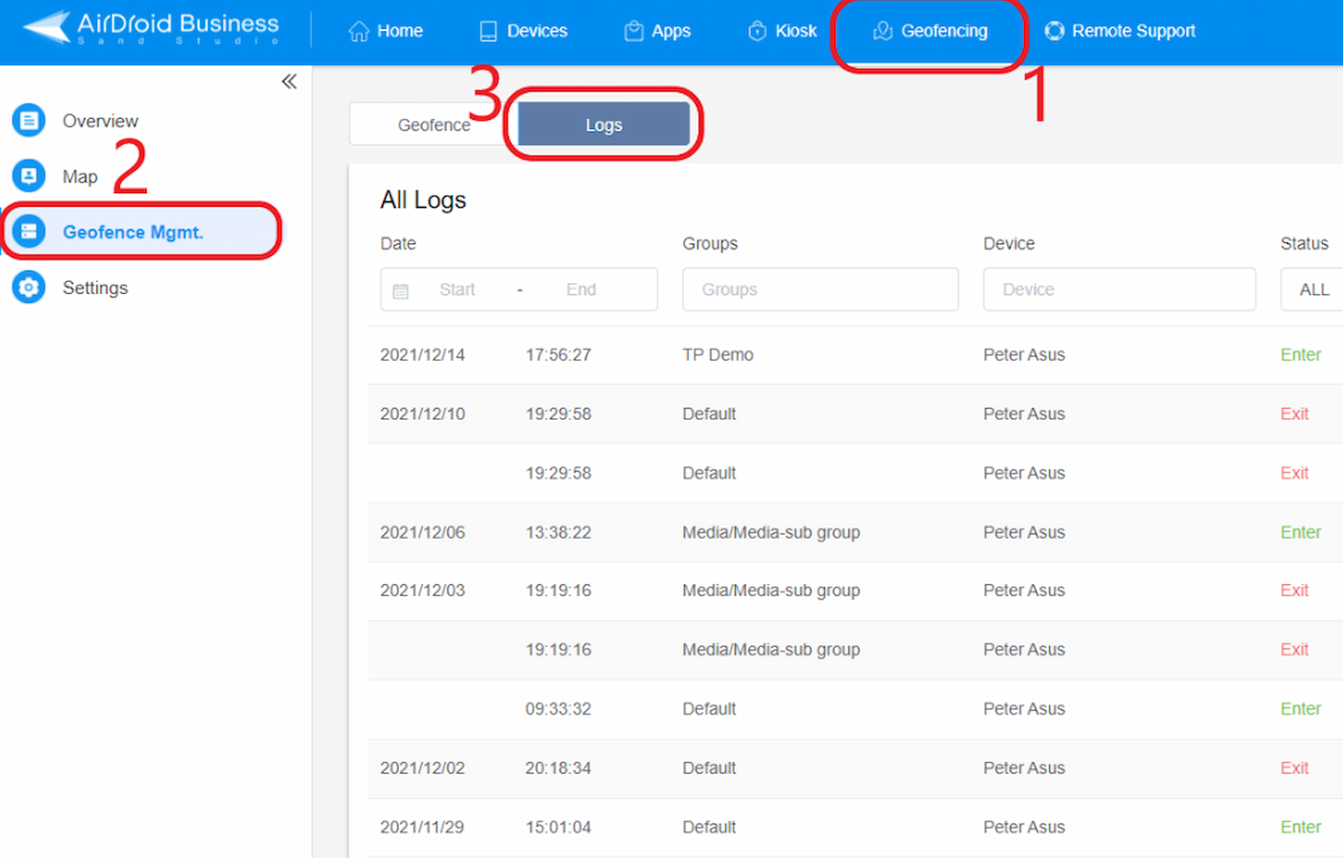
AirDroid ahora incluye funciones para rastrear ubicaciones de negocios, lo que lo convierte en una opción ideal para empresas con equipos que trabajan en el campo.
Por qué elegí AirDroid: Después de seleccionar y evaluar varias herramientas de rastreo de ubicación, la reputación y características de AirDroid llamaron mi atención. Se diferencia por su capacidad dual: gestión de dispositivos y seguimiento de ubicaciones. Elegí AirDroid para esta lista porque muchas herramientas ofrecen servicios de ubicación, pero pocas los combinan de manera efectiva con una gestión integral de dispositivos, lo cual es fundamental para las empresas con equipos móviles.
Características y integraciones destacadas:
Una de las características más importantes de AirDroid es el seguimiento en tiempo real de múltiples dispositivos, asegurando que las empresas tengan actualizaciones instantáneas sobre la ubicación de sus equipos. Además, su gestión remota integrada de dispositivos permite controlar funcionalidades del equipo, mejorando la seguridad y la eficiencia operativa.
El ecosistema de AirDroid admite integraciones con varias herramientas empresariales principales, lo que facilita un flujo de operaciones más cohesivo.
Pros and Cons
Pros:
- El rastreo en tiempo real de múltiples dispositivos brinda actualizaciones inmediatas de ubicación
- La gestión integrada de dispositivos garantiza una mayor seguridad del equipo
- Admite integraciones con una variedad de herramientas empresariales
Cons:
- Algunas funciones pueden ser excesivas para empresas que solo buscan rastrear ubicaciones
- La interfaz puede resultar abrumadora para usuarios primerizos
- Requiere conexión a internet para la mayoría de las funciones, lo que limita el uso sin conexión
Palo Alto Networks GlobalProtect ofrece avanzados servicios de geoperimetraje que priorizan la seguridad. Al integrar servicios de geolocalización con su infraestructura de seguridad de alto nivel, GlobalProtect proporciona a las empresas conocimientos basados en la ubicación y medidas de seguridad inigualables.
Por qué elegí Palo Alto Networks GlobalProtect: Al seleccionar herramientas de geolocalización, GlobalProtect de Palo Alto Networks destacó claramente debido a su integración de geoperimetraje con rigurosos protocolos de seguridad. Tras comparar múltiples opciones, comprobé que su compromiso con la seguridad mientras ofrece servicios de geolocalización lo distingue del resto. Elegí GlobalProtect porque su enfoque en la seguridad coincide con la creciente demanda de geoperimetría protegida, lo que lo hace ideal para la geoperimetría centrada en la seguridad.
Características destacadas & integraciones:
GlobalProtect cuenta con autenticación multifactor para garantizar que solo los usuarios autorizados accedan a los datos geoperimetrados. También ofrece protección de endpoints, resguardando dispositivos fuera del perímetro de la red.
En cuanto a integraciones, GlobalProtect es compatible con una amplia gama de herramientas de infraestructura de red, soluciones de seguridad y plataformas de análisis de datos, mejorando su versatilidad.
Pros and Cons
Pros:
- Énfasis en la seguridad con capacidades de geoperimetraje
- La autenticación multifactor garantiza protección adicional
- Amplia variedad de integraciones para aplicaciones diversas
Cons:
- Puede ser más complejo para usuarios no familiarizados con los protocolos de seguridad
- La facturación anual puede disuadir a algunos usuarios potenciales
- Las funciones premium de seguridad pueden ser excesivas para algunas pequeñas empresas
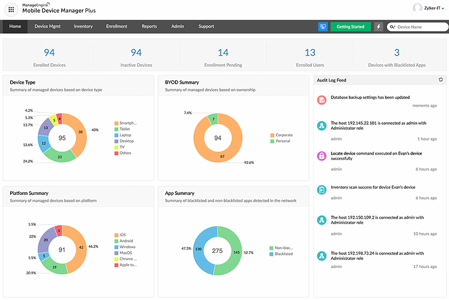
ManageEngine MDM utiliza la geovalla para ayudar a las empresas a gestionar dispositivos móviles de manera efectiva.
Por qué elegí el software de geovallas de ManageEngine MDM: Tras comparar varias soluciones MDM, el software de geovallas de ManageEngine destacó como un fuerte competidor. Su compromiso de entrelazar capacidades de geovalla con una gestión robusta de dispositivos móviles lo hizo distintivo. Elegí esta herramienta porque sus funciones se alinean con los requisitos de las empresas para una gestión integral de dispositivos y geovallas.
Funciones destacadas e integraciones:
ManageEngine es reconocido por su análisis detallado de dispositivos, lo que permite a las empresas obtener información profunda sobre el uso de los dispositivos y los datos de ubicación. Además, sus configuraciones de geovallas personalizables aseguran que las empresas puedan establecer límites precisos y recibir alertas instantáneas en caso de infracción.
El software presume de capacidades de integración con una gran variedad de sistemas empresariales, lo que aumenta su adaptabilidad y facilidad de uso en diversos entornos empresariales.
Pros and Cons
Pros:
- El análisis detallado de dispositivos ofrece información profunda
- Configuraciones de geovalla personalizables que se adaptan a necesidades empresariales específicas
- Se integra con muchos sistemas empresariales
Cons:
- Puede ser complejo para empresas que sólo necesitan geovallas básicas
- La curva de aprendizaje para aprovechar al máximo todas las funciones
- Depende en gran medida de la conectividad continua a internet
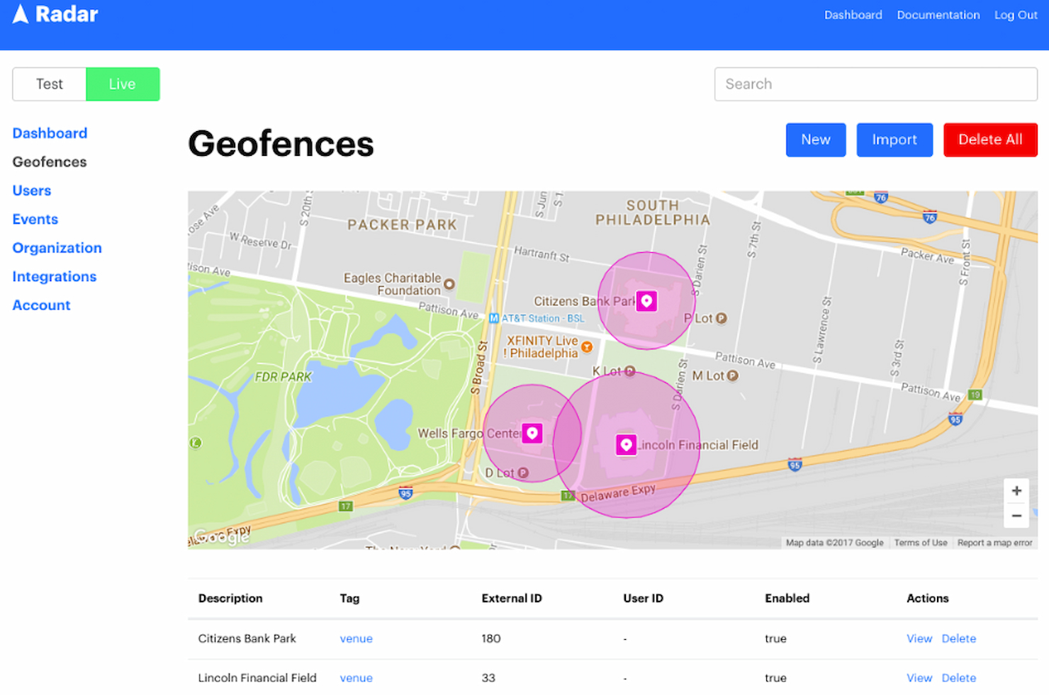
Radar es una plataforma de datos de ubicación que facilita el desarrollo de aplicaciones basadas en geovallas. Debido a su versatilidad, sirve adecuadamente a empresas de una gran variedad de sectores, convirtiéndose en una opción principal para quienes buscan soluciones diversas de geovallas.
Por qué elegí Radar: En mi búsqueda para identificar las mejores plataformas de geovallas, Radar surgió como un fuerte competidor. Su versatilidad es especialmente destacable, ya que puede atender a una mezcla ecléctica de necesidades empresariales. A mi juicio, cuando se trata de aplicaciones diversas de geovallas, Radar destaca como la solución más adaptable y robusta disponible.
Funciones destacadas e integraciones:
Radar cuenta con funciones como el seguimiento del estado del usuario, que proporciona información sobre el comportamiento de los usuarios dentro y alrededor de las geovallas. La plataforma también admite geovallas dinámicas, que pueden ajustarse en tiempo real en función de la interacción del usuario.
En cuanto a integraciones, Radar se conecta con varias herramientas empresariales, plataformas de análisis y sistemas de automatización de marketing, asegurando que los datos de geolocalización puedan utilizarse en diferentes marcos operativos.
Pros and Cons
Pros:
- Ofrece información detallada sobre las interacciones de los usuarios con las geovallas
- Admite ajustes dinámicos de geovallas en tiempo real
- Amplia variedad de opciones de integración con herramientas empresariales y de marketing
Cons:
- Puede tener una curva de aprendizaje para quienes no estén familiarizados con las geovallas
- La gran cantidad de funciones puede resultar abrumadora para algunos usuarios
- Dependiendo de la integración, puede haber retrasos ocasionales en la sincronización
El SDK de geocercado de Woosmap se presenta como una herramienta sobresaliente diseñada para desarrolladores que buscan integrar capacidades de geocercado en sus aplicaciones. Sus funciones completas se ajustan a las necesidades de los desarrolladores en cuanto a SDK, lo que la convierte en una opción destacada para quienes trabajan en el ámbito del desarrollo.
Por qué elegí el SDK de geocercado de Woosmap: Elegí el SDK de geocercado de Woosmap como mi principal elección entre las diferentes herramientas de geocercado que comparé. Ofrece funciones potentes orientadas a los desarrolladores, abordando sus desafíos habituales. Su énfasis en las necesidades de SDK lo convierte en la opción ideal para quienes trabajan con estos requisitos.
Características destacadas e integraciones:
Una de las características estrella de Woosmap es su capacidad de geocercado en tiempo real, que permite a los desarrolladores implementar soluciones de geocercado dinámico. Además, el SDK ofrece herramientas de análisis detallado, proporcionando información sobre las interacciones del usuario y el comportamiento dentro de las regiones geocercadas.
En cuanto a las integraciones, Woosmap se integra con varios servicios de mapas, sistemas CRM y servicios de notificaciones, lo que añade versatilidad a sus aplicaciones.
Pros and Cons
Pros:
- Adaptado para desarrolladores con herramientas SDK completas
- Capacidades de geocercado en tiempo real para interacciones dinámicas
- Amplias opciones de integración con plataformas populares
Cons:
- Puede ser demasiado técnico para quienes no son desarrolladores
- El precio puede ser elevado para proyectos pequeños
- Requiere actualizaciones periódicas para un rendimiento óptimo

Purple es conocido por combinar capacidades de geoperimetraje con avanzadas soluciones de guiado. Su destreza en ofrecer a los usuarios orientación precisa mientras los mantiene conscientes de su ubicación consolida su posición como la opción principal para la integración de sistemas de guiado.
Por qué elegí Purple: Entre la gran cantidad de software de geoperimetraje que evalué, Purple destacó notablemente. Elegí Purple por encima de otros debido a su capacidad única de no solo delimitar zonas geográficas, sino también incorporar herramientas avanzadas de guiado. Dada la creciente necesidad de herramientas que puedan guiar a los usuarios con precisión mientras integran la geolocalización, Purple se presenta como líder claro en este nicho.
Características y integraciones destacadas:
El principal atractivo de Purple son sus avanzadas herramientas de guiado, que permiten a las empresas orientar a sus usuarios con gran precisión. Sus herramientas incluyen desde recomendaciones de rutas dinámicas hasta opciones de accesibilidad para diversos tipos de usuario.
En cuanto a integraciones, Purple se integra bien con los sistemas CRM más populares, sistemas POS e incluso algunos dispositivos avanzados de IoT, lo que hace que sus aplicaciones sean amplias y variadas.
Pros and Cons
Pros:
- Herramientas superiores de guiado con recomendaciones dinámicas
- Alta compatibilidad con sistemas CRM y POS
- Capacidades de integración con dispositivos IoT
Cons:
- Puede ser demasiado especializado para quienes solo buscan geoperimetraje básico
- Requiere actualizaciones periódicas para mantener la precisión del guiado
- Curva de aprendizaje más pronunciada para quienes no están familiarizados con herramientas de guiado
Gimbal Location Platform ofrece una solución completa de geolocalización con herramientas para recopilar, analizar y utilizar datos de ubicación. Brinda capacidades avanzadas para explorar información basada en la ubicación, proporcionando una comprensión integral de cualquier lugar.
Por qué elegí Gimbal Location Platform: En mi recorrido comparando varias plataformas, escogí Gimbal Location Platform por su amplitud y profundidad de funcionalidades de ubicación. Destacó por sus características todo en uno, brindando una visión completa de los datos de geolocalización. Esta naturaleza integral consolidó mi opinión de que es la mejor opción para empresas que buscan una visión amplia en analítica de ubicación.
Características destacadas e integraciones:
Gimbal ofrece geocercas, balizas y analíticas detalladas de ubicación. Esta suite asegura que las empresas puedan capturar, interpretar y actuar con precisión sobre los datos de ubicación. Gimbal se integra fácilmente con diversas herramientas de datos de terceros y CRMs, aportando una visión sinérgica de los datos y conocimientos accionables.
Pros and Cons
Pros:
- Conjunto de herramientas completo que incluye geocercas, balizas y analíticas
- Se integra eficazmente con múltiples herramientas de datos de terceros y CRMs
- Ofrece información de ubicación detallada y accionable
Cons:
- El precio inicial es elevado
- Es obligatorio el compromiso anual
- Posible curva de aprendizaje pronunciada para usuarios nuevos
GeoComply ofrece servicios de geolocalización personalizados para ayudar a las empresas a cumplir con las regulaciones y prevenir el fraude. Es la opción preferida tanto para el cumplimiento normativo como para la prevención del fraude.
Por qué elegí GeoComply: Seleccioné GeoComply para esta lista tras examinar detenidamente varios servicios de geolocalización. El compromiso de la herramienta con el cumplimiento regulatorio y sus mecanismos inherentes de detección de fraude la distinguen de otras ofertas en el mercado. Para mí está claro que GeoComply destaca especialmente en la prevención del fraude y en garantizar el cumplimiento.
Funciones destacadas e integraciones:
GeoComply impresiona con su recopilación de datos de geolocalización en tiempo real, lo que garantiza una precisión actualizada al minuto. Su precisión exacta y las zonas de cumplimiento personalizables proporcionan a las empresas las herramientas necesarias para disuadir el fraude de manera efectiva.
En cuanto a integraciones, GeoComply ha establecido alianzas con una amplia gama de plataformas y sistemas en línea, consolidando su adaptabilidad en entornos operativos diversos.
Pros and Cons
Pros:
- Datos de geolocalización en tiempo real para máxima precisión
- Ofrece zonas de cumplimiento personalizables adaptadas a las empresas
- Amplias capacidades de integración con diversas plataformas en línea
Cons:
- Puede ser excesivo para empresas con necesidades mínimas de cumplimiento
- Requiere conexión a internet continua para funcionar de manera efectiva
- Complejidad potencial en la configuración para usuarios primerizos

Bluedot ofrece servicios de geolocalización especializados, enfocados en lograr un seguimiento de ubicación preciso para diversas aplicaciones. Con la creciente demanda de información detallada y exacta basada en la ubicación, Bluedot proporciona datos de ubicación de alta precisión para las empresas.
Por qué elegí Bluedot: Elegí Bluedot por sus herramientas de geolocalización debido a su enfoque en la precisión y sus algoritmos únicos. Ofrece servicios de ubicación precisos, lo cual es crucial para las empresas que necesitan información detallada de ubicación.
Características e integraciones destacadas:
Una de las características distintivas de Bluedot es su capacidad para precisar los datos de ubicación con detalle, brindando análisis que muchas herramientas pasan por alto. Además, Bluedot soporta geoperimetraje dinámico, adaptándose a los cambios del mundo real casi al instante.
En cuanto a las integraciones, Bluedot funciona sin problemas con diversas plataformas de marketing, herramientas de análisis y sistemas CRM, facilitando la transferencia y el análisis de datos.
Pros and Cons
Pros:
- Precisión excepcional en el seguimiento de ubicaciones
- El geoperimetraje dinámico se ajusta a condiciones en tiempo real
- Amplia gama de integraciones para aplicaciones empresariales
Cons:
- Puede resultar más complejo para quienes buscan funciones básicas de geolocalización
- La facturación anual puede no ser atractiva para todos los usuarios potenciales
- Las funciones de precisión pueden tener una curva de aprendizaje más pronunciada para algunos usuarios

PlotProjects ofrece soluciones personalizadas de geolocalización para mejorar las estrategias de marketing y aumentar el compromiso de los clientes de manera más eficaz con tecnologías avanzadas basadas en la ubicación.
Por qué elegí PlotProjects: Al comparar y evaluar varias herramientas de geolocalización, PlotProjects destacó como líder en su nicho, diseñada específicamente para los profesionales del marketing. Su combinación única de funciones, centradas en la ubicación y la interacción con el cliente, la diferencia de otras herramientas del mercado. Elegí PlotProjects porque su propuesta está alineada directamente con las necesidades de las empresas que buscan aprovechar los datos de ubicación para incrementar el compromiso y la eficacia de sus estrategias de marketing.
Funciones destacadas e integraciones:
PlotProjects cuenta con funciones como la geolocalización en tiempo real, lo que permite a las empresas enviar notificaciones oportunas a su público en función de su ubicación. Además, ofrece análisis avanzados que brindan información sobre el comportamiento y los patrones de interacción de los clientes.
En cuanto a integraciones, PlotProjects se adapta bien a muchas plataformas de marketing, sistemas CRM e incluso herramientas populares de comercio electrónico, facilitando un flujo de trabajo cohesivo para las empresas.
Pros and Cons
Pros:
- Geolocalización en tiempo real para interacciones inmediatas con los clientes
- Análisis completos que ofrecen información sobre los patrones de interacción
- Amplia variedad de opciones de integración con herramientas de marketing populares
Cons:
- Puede ser demasiado complejo para negocios que solo buscan soluciones básicas de geolocalización
- El precio puede ser elevado para pequeñas empresas
- Requiere una curva de aprendizaje para quienes no están familiarizados con técnicas avanzadas de marketing
Otro Software de Geovallado
Aquí tienes algunas opciones adicionales de software de geovallado que no entraron en mi lista principal, pero que aún vale la pena revisar:
- Roam.ai Geofencing API
Ideal para geolocalización impulsada por API
- LocationSmart
Mejor para necesidades de geolocalización escalables
- Scalefusion
Ideal para la gestión unificada de terminales multiplataforma


Cómo Evalúo el Software de Geovallas
Evalúo las herramientas de geovallas en dos niveles: el estándar que toda plataforma debe tener—geovallas poligonales, entrega de anuncios móviles y atribución de visitas—y los factores que diferencian a un proveedor de otro.
Funcionalidad Básica (Requisitos Fundamentales para Esta Lista)
Estas capacidades básicas sirven como criterios de aceptación para la inclusión en mi lista de software de geovallas:
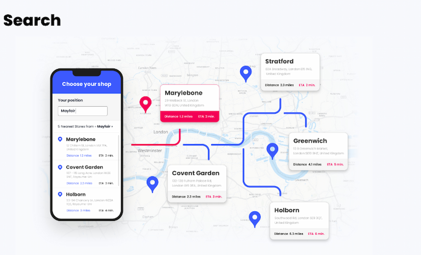
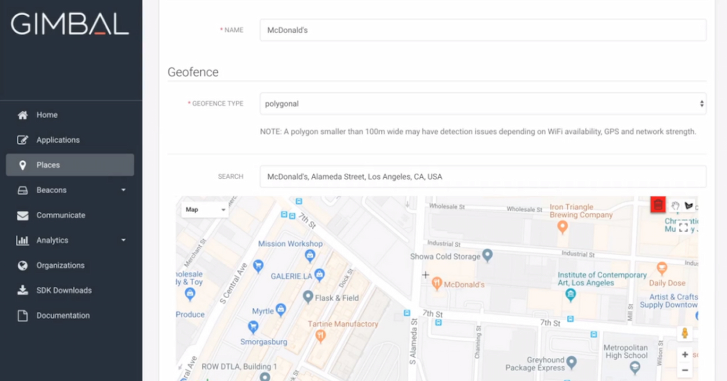
- Creación Personalizada de Geovallas: Verifico si una plataforma permite tanto geovallas de radio como poligonales para que puedas delimitar el estacionamiento de un competidor o una manzana completa alrededor de un lugar.
- Entrega de Anuncios Móviles: El soporte de formatos de anuncios y el acceso al inventario de cada proveedor son importantes—busco entrega de display, video y formatos nativos, tanto en web móvil como en aplicaciones.
- Reorientación de Audiencias: Evalúo cuánto tiempo una plataforma retiene identificadores de dispositivos capturados y si permite emparejamiento entre dispositivos para volver a atraer compradores que visitaron un stand semanas atrás.
- Atribución de Tráfico Peatonal: Conectar impresiones de anuncios con visitas reales a tiendas es el objetivo principal, así que busco medición de incremento por grupo de control y reportes de visitas por ubicación.
- Datos de Ubicación y Segmentación: Las plataformas que combinan señales de GPS, Wi-Fi y SDK con filtros demográficos o de comportamiento ofrecen un alcance más preciso que aquellas que dependen solo de IP.
- Panel Analítico de Campañas: Evalúo si los reportes van más allá de clics e impresiones para mostrar incremento de visitas, tiempo de permanencia y mapas de calor geográficos en tiempo real.
Califico a cada proveedor en una escala del 0 (no ofrece la funcionalidad) al 5 (excelente en esta área) para cada criterio.
Los proveedores deben alcanzar una puntuación media mínima para ser considerados en mi lista. A partir de ahí, considero lo que distingue a cada plataforma.
Factores Diferenciales (Lo Que Distingue a los Proveedores)
Una vez que he seleccionado mi lista, así es como contrasto y comparo distintos proveedores en el espacio del software de geovallas:
Características Destacadas
Busco herramientas de conquista competitiva que permitan focalizar instantáneamente ubicaciones rivales en distintas regiones, y geovallas direccionables que permiten una segmentación precisa de hogares para campañas tipo correo directo. La profundidad en la incorporación de datos de CRM y offline también es clave—los proveedores que pueden incorporar datos de compras propios o crear audiencias similares a partir de visitantes anteriores ofrecen flujos de segmentación más sofisticados. Para anunciantes de eventos, las herramientas de segmentación por eventos y recintos que soportan geovallas programadas y acotadas en el tiempo aportan verdadero valor.
Más Allá de las Funcionalidades
El cumplimiento en privacidad de datos es una consideración principal—verifico cómo maneja cada proveedor exclusiones de ubicaciones sensibles, gestión de consentimientos y su preparación para marcos de identidad post-IDFA. El modelo de servicio también es crucial: algunos equipos necesitan un servicio completamente gestionado con un estratega dedicado, mientras que otros desean acceso autogestionado para crear y optimizar campañas por sí mismos. También evalúo integraciones con los stacks existentes, especialmente la conectividad con plataformas analíticas, CDPs y proveedores de atribución offline en los que los equipos de marketing ya confían.
Cómo Elegir un Software de Geovallado
Es fácil perderse en extensas listas de funciones y estructuras de precios complejas. Para ayudarte a mantener el enfoque mientras trabajas en tu proceso de selección, aquí tienes una lista de factores clave a considerar:
| Factor | Qué Considerar |
|---|---|
| Escalabilidad | ¿Puede el software crecer con tu empresa? Considera los límites de usuarios y lo fácil que es ampliar los servicios a medida que aumentan tus necesidades. Ten cuidado con los costes ocultos. |
| Integraciones | ¿Funciona con tus herramientas actuales? Verifica la compatibilidad con tu CRM, analíticas u otras plataformas para evitar interrupciones en los flujos de trabajo. |
| Personalización | ¿Puedes adaptar el software a tus procesos? Busca opciones para ajustar configuraciones y funciones a necesidades específicas sin codificación extensa. |
| Facilidad de uso | ¿La interfaz es intuitiva para tu equipo? Prueba la demo y verifica que los miembros del equipo puedan navegar sin capacitación exhaustiva. |
| Implementación y onboarding | ¿Cuánto demorará la configuración? Evalúa la complejidad de la instalación inicial y los recursos requeridos para una integración exitosa. |
| Costo | ¿El precio se adapta a tu presupuesto? Compara modelos de suscripción y busca tarifas adicionales o complementos requeridos que puedan afectar el coste total. |
| Medidas de seguridad | ¿Se implementan medidas para proteger los datos? Asegúrate de que el software cumpla los estándares de seguridad pertinentes y ofrezca cifrado y controles de acceso. |
¿Qué es un Software de Geovallado?
El software de geovallado es una herramienta que establece límites virtuales alrededor de ubicaciones físicas utilizando GPS, Wi-Fi o datos móviles. Los equipos de marketing, gestores de servicios de campo, equipos de seguridad y operadores de flotas lo utilizan para recibir alertas o activar acciones cuando personas o equipos entran o salen de un área. Esto te ayuda a rastrear equipos móviles, enviar mensajes basados en la ubicación y supervisar activos, facilitando las operaciones diarias.
Funciones
Al seleccionar software de geovallado, presta atención a las siguientes características clave:
- Seguimiento en tiempo real: Monitorea la ubicación de activos o personas al instante, ayudándote a tomar decisiones a tiempo.
- Notificaciones basadas en ubicación: Envía alertas o mensajes al entrar o salir de áreas designadas, mejorando el compromiso y el control operativo.
- Geotargeting: Dirige usuarios según su ubicación para campañas de marketing personalizadas, aumentando la relevancia y el impacto.
- Geovallas personalizables: Permite definir áreas específicas para su monitoreo, ofreciendo flexibilidad para satisfacer distintas necesidades.
- Análisis de datos e informes: Ofrece información sobre actividades basadas en la ubicación, ayudando a analizar tendencias y tomar decisiones informadas.
- Capacidades de integración: Se conecta con sistemas existentes como CRM o dispositivos IoT, asegurando un flujo de datos fluido entre plataformas.
- Controles de privacidad: Garantiza que los datos de usuarios se gestionen de forma segura, cumpliendo con las regulaciones de privacidad pertinentes.
- Facilidad de uso: Cuenta con una interfaz intuitiva que simplifica la navegación y reduce la curva de aprendizaje para los usuarios.
- Soporte multilingüe: Ofrece accesibilidad a una base global de usuarios, mejorando la usabilidad en distintas regiones.
- Recursos de capacitación y soporte: Proporciona materiales de aprendizaje y atención al cliente para facilitar el uso eficaz de la herramienta y la resolución de problemas.
Beneficios
Implementar software de geovallado ofrece varios beneficios para tu equipo y tu empresa. A continuación, algunos de los que puedes esperar:
- Mejor segmentación: El geotargeting te permite llegar al público adecuado según la ubicación, mejorando la efectividad del marketing.
- Mayor eficiencia operativa: El seguimiento en tiempo real te ayuda a monitorear activos y personal, permitiendo decisiones rápidas.
- Mayor compromiso: Las notificaciones basadas en la ubicación mantienen a los usuarios informados y comprometidos con información oportuna.
- Mejores datos e insights: Las funciones de análisis e informes proporcionan información valiosa sobre actividades basadas en la ubicación, apoyando la planificación estratégica.
- Flexibilidad y personalización: Las geovallas personalizables te permiten adaptar la herramienta a necesidades específicas, brindando versatilidad en varias aplicaciones.
- Seguridad y cumplimiento: Los controles de privacidad aseguran la protección de datos, alineando las operaciones con las regulaciones pertinentes.
- Facilidad de integración: Las capacidades de integración permiten una conexión fluida con sistemas existentes, mejorando la continuidad del flujo de trabajo.
Costos y precios
Seleccionar un software de geovallado requiere entender los diferentes modelos y planes de precios disponibles. Los costos varían según las funciones, el tamaño del equipo, complementos y más. La siguiente tabla resume los planes comunes, sus precios promedio y las características típicas incluidas en las soluciones de software de geovallado:
Tabla comparativa de planes de software de geovallado
| Tipo de Plan | Precio Promedio | Funciones Comunes |
|---|---|---|
| Plan gratuito | $0 | Geovallado básico, notificaciones limitadas y soporte comunitario. |
| Plan personal | $10-$30/user/month | Notificaciones avanzadas, geovallas personalizables y análisis básico. |
| Plan empresarial | $50-$100/user/month | Seguimiento en tiempo real, capacidades de integración y controles de privacidad mejorados. |
| Plan para empresas | $150-$300/user/month | Análisis integral, soporte dedicado y opciones de personalización total. |
Preguntas frecuentes sobre software de geovallas
Aquí tienes respuestas a las preguntas más comunes sobre el software de geovallas:
¿Cómo integro el software de geovallas con nuestra pila tecnológica existente?
Puedes integrar el software de geovallas utilizando APIs, SDKs o webhooks proporcionados por las principales plataformas. La mayoría de las soluciones empresariales admiten los lenguajes de programación más populares y ofrecen documentación técnica detallada para desarrolladores. Busca opciones que puedan conectarse con tu CRM, aplicaciones móviles o servicios de ubicación actuales. Realiza pruebas de integración en un entorno sandbox antes de implementar en producción. Si tienes sistemas heredados, verifica la disponibilidad de middleware o consulta al proveedor para soporte de integración personalizada.
¿Qué consideraciones de privacidad de datos o cumplimiento conlleva el software de geovallas?
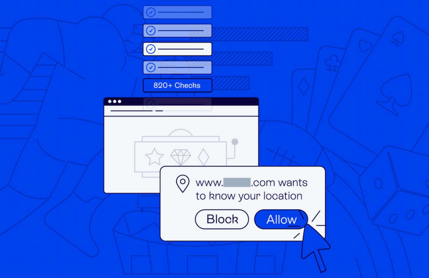
Debes asegurarte de que tu software de geovallas cumpla con las leyes de privacidad de datos regionales como GDPR o CCPA. Los datos de ubicación son sensibles, por lo que debes priorizar proveedores que ofrezcan cifrado de datos, políticas personalizables de retención de datos y herramientas claras para el consentimiento del usuario. Evalúa si los datos de ubicación se almacenan, transmiten o procesan localmente o en la nube. Colabora estrechamente con tus equipos legales y de cumplimiento para establecer permisos y procesos de auditoría.
¿Puede el software de geovallas escalar con una fuerza laboral o flota global?
Sí, la mayoría de las soluciones de geovallas de nivel empresarial pueden escalar a nivel global. Elige un software con soporte multirregional, infraestructura de alta disponibilidad y límites robustos en llamadas API. Verifica que la plataforma admita un gran número de geovallas simultáneas y seguimiento en tiempo real. Si gestionas una fuerza laboral o flota distribuida, confirma la compatibilidad con varios tipos de dispositivos y redes de telecomunicaciones locales.
¿Qué tan fiable es el geovallado en entornos con GPS irregular o mala conectividad?
El software de geovallas puede manejar señales GPS poco fiables o conexiones celulares débiles, aunque los resultados pueden variar. Busca plataformas que admitan activadores basados en Wi-Fi o Bluetooth como respaldo. Algunas herramientas utilizan tecnología híbrida de ubicación para mejorar la precisión en interiores o en zonas urbanas complejas. Siempre haz una prueba piloto de la solución en los entornos más difíciles para evaluar retrasos, alertas falsas o registros perdidos antes de una implementación completa.
¿Qué sigue?
Si estás investigando software de geovallas, conéctate con un asesor de SoftwareSelect para recibir recomendaciones gratuitas.
Solo tienes que completar un formulario y mantener una breve conversación para profundizar en los detalles de tus necesidades. Después, recibirás una lista corta de software para revisar. Incluso te acompañarán durante todo el proceso de compra, incluidas las negociaciones de precios.