Mappare il Futuro: I 10 Migliori Software di Geofencing del 2026

Migliori Software di Geofencing - Shortlist


Il software di geofencing ti consente di automatizzare azioni basate sulla posizione, inviare avvisi istantanei quando gli utenti entrano o escono da zone predefinite e gestire compiti come il tracciamento della forza lavoro, il monitoraggio dei beni e il marketing mirato con precisione. Le migliori soluzioni risolvono problemi frustranti come confini GPS inaffidabili, interfacce macchinose o trigger che non si attivano—così puoi mantenere il controllo su ogni evento basato sulla posizione.
Ho testato personalmente queste piattaforme su dispositivi mobili e in diversi tipi di implementazioni, rendendo più facile per te scegliere un software che sia preciso, facile da usare e flessibile per il flusso di lavoro del tuo team.
Why Trust Our Software Reviews
We’ve been testing and reviewing software since 2023. As tech leaders ourselves, we know how critical and difficult it is to make the right decision when selecting software.
We invest in deep research to help our audience make better software purchasing decisions. We’ve tested more than 2,000 tools for different tech use cases and written over 1,000 comprehensive software reviews. Learn how we stay transparent & our software review methodology.
Riepilogo Migliori Software di Geofencing
Questa tabella comparativa riassume i dettagli sui prezzi delle mie migliori selezioni di software di geofencing per aiutarti a trovare quello più adatto al tuo budget e alle esigenze della tua azienda.
| Tool | Best For | Trial Info | Price | ||
|---|---|---|---|---|---|
| 1 | Best for business location tracking | Free demo available | From $1/device/month (billed annually) | Website | |
| 2 | Best for security-focused geofencing | Not available | From $15/user/month (billed annually) | Website | |
| 3 | Best for mobile device management | Not available | From $15/user/month (billed annually) | Website | |
| 4 | Best for diverse geofencing applications | Not available | Pricing upon request | Website | |
| 5 | Best for developers and SDK needs | Not available | From $15/user/month (billed annually) + $30 base fee per month | Website | |
| 6 | Best for wayfinding integration | Not available | From $20/user/month (billed annually) | Website | |
| 7 | Best for comprehensive location insights | Not available | From $50/user/month (billed annually) | Website | |
| 8 | Best for fraud prevention and compliance | Not available | Pricing upon request | Website | |
| 9 | Best for precision location services | Not available | From $12/user/month (billed annually) | Website | |
| 10 | Best for marketing and engagement | Not available | From $15/user/month (billed annually) | Website |
-

TestDevLab
Visit Website -
Site24x7
Visit WebsiteThis is an aggregated rating for this tool including ratings from Crozdesk users and ratings from other sites.4.7 -
GitHub Actions
Visit WebsiteThis is an aggregated rating for this tool including ratings from Crozdesk users and ratings from other sites.4.8


Recensione Migliori Software di Geofencing
Qui sotto trovi i miei riepiloghi dettagliati dei migliori software di geofencing che ho incluso nella mia shortlist. Le mie recensioni offrono una visione approfondita di funzionalità chiave, pro e contro, integrazioni e casi d’uso ideali di ogni strumento, per aiutarti a trovare quello più adatto a te.

AirDroid now includes features for tracking business locations, making it an ideal option for businesses with teams working in the field.
Why I Picked AirDroid: After selecting and evaluating various location-tracking tools, AirDroid's reputation and offerings caught my attention. It differentiates itself with its dual capabilities - device management and location tracking. I chose AirDroid for this list because many tools offer location services, but few combine it effectively with comprehensive device management, which is pivotal for businesses with mobile teams.
Standout features & integrations:
One of AirDroid’s paramount features is tracking multiple devices in real time, ensuring that businesses have up-to-the-minute updates on their teams' whereabouts. In addition, its integrated remote device management allows for control over device functionalities, enhancing security and operational efficiency.
AirDroid's ecosystem supports integrations with several primary enterprise tools, enabling a more cohesive business operations flow.
Pros and Cons
Pros:
- Supports integrations with a variety of enterprise tools
- Integrated device management ensures enhanced device security
- Real-time multi-device tracking provides immediate location updates
Cons:
- Requires internet connectivity for most functionalities, limiting offline use
- The interface can be overwhelming for first-time users
- Some features might be overkill for businesses only seeking location tracking

Palo Alto Networks GlobalProtect offers advanced geofencing services that prioritize security. By integrating geolocation services with its high-tier security infrastructure, GlobalProtect provides businesses with location-based insights and unmatched safety measures.
Why I Picked Palo Alto Networks GlobalProtect: In selecting geolocation tools, GlobalProtect by Palo Alto Networks distinctly emerged due to its integration of geofencing with stringent security protocols. After comparing multiple options, I found that its commitment to security while offering geolocation services sets it apart. I chose GlobalProtect because its focus on security coincides with the increasing demand for protected geofencing, making it best for security-focused geofencing.
Standout features & integrations:
GlobalProtect boasts multi-factor authentication to ensure only authorized users access the geofenced data. It also provides endpoint protection, safeguarding devices outside the network's perimeter.
In terms of integrations, GlobalProtect is compatible with a range of network infrastructure tools, security solutions, and data analysis platforms, enhancing its versatility.
Pros and Cons
Pros:
- Wide range of integrations for diverse applications
- Multi-factor authentication ensures added protection
- Emphasis on security with geofencing capabilities
Cons:
- Premium security features might be overkill for some smaller businesses
- Annual billing might deter some potential users
- May be more complex for users unfamiliar with security protocols

ManageEngine MDM uses geofencing to help businesses manage mobile devices effectively.
Why I Picked ManageEngine MDM Geofencing Software: After comparing several MDM solutions, ManageEngine's geofencing software emerged as a strong contender. Its commitment to intertwining geofencing capabilities with robust mobile device management made it distinct. I chose this tool because its capabilities align with businesses’ requirements for comprehensive device management and geofencing.
Standout features & integrations:
ManageEngine is renowned for its detailed device analytics, allowing businesses to gain in-depth insights into device usage and location data. Furthermore, its customizable geofence settings ensure that businesses can set precise boundaries and receive instant alerts for any breaches.
The software boasts integration capabilities with a plethora of enterprise systems, enhancing its adaptability and ease of use in varied business environments.
Pros and Cons
Pros:
- Integrates with many enterprise systems
- Customizable geofence settings cater to specific business needs
- Detailed device analytics provide in-depth insights
Cons:
- Relies heavily on continuous internet connectivity
- The learning curve for maximizing all features
- Can be complex for businesses only needing basic geofencing

Radar is a location data platform that facilitates the development of geofencing-based applications. Given its versatility, it aptly serves businesses in a myriad of sectors, making it a primary choice for those seeking diverse geofencing solutions.
Why I Picked Radar: In my quest to identify the best geofencing platforms, Radar emerged as a strong contender. Its versatility is particularly noteworthy, capable of serving an eclectic mix of business needs. In my judgment, when it comes to diverse geofencing applications, Radar stands out as the most adaptable and robust solution available.
Standout features & integrations:
Radar boasts features such as user state tracking, which provides insights into user behavior in and around geofences. The platform also supports dynamic geofences which can be adjusted in real-time based on user interaction.
In terms of integrations, Radar connects with various business tools, analytics platforms, and marketing automation systems, ensuring that the geolocation data can be utilized across different operational frameworks.
Pros and Cons
Pros:
- Wide array of integration options with business and marketing tools
- Supports dynamic adjustments of geofences in real-time
- Provides detailed insights into user interactions with geofences
Cons:
- Depending on the integration, there may be occasional synchronization delays
- The vast array of features might be overwhelming for some users
- Might have a learning curve for those unfamiliar with geofencing

Woosmap Geofencing SDK stands as a remarkable tool tailored for developers seeking to integrate geofencing capabilities into their applications. Its comprehensive features align with developers' SDK needs, making it a prime choice for those in the development realm.
Why I Picked Woosmap Geofencing SDK: I chose Woosmap Geofencing SDK as my top choice among the different geofencing tools I compared. It offers strong features geared towards developers, addressing their common challenges. Its emphasis on SDK needs makes it ideal for those with SDK requirements.
Standout features & integrations:
One of Woosmap's flagship features is its real-time geofencing capabilities, allowing developers to implement dynamic geofencing solutions. Additionally, the SDK provides tools for detailed analytics, giving insights into user interactions and behavior within geofenced regions.
As for integrations, Woosmap harmonizes with various mapping services, CRM systems, and notification services, adding versatility to its applications.
Pros and Cons
Pros:
- Wide range of integration options with popular platforms
- Real-time geofencing capabilities for dynamic interactions
- Tailored for developer needs with comprehensive SDK tools
Cons:
- Requires periodic updates for optimal performance
- Pricing can be steep for small projects
- Might be too technical for non-developers
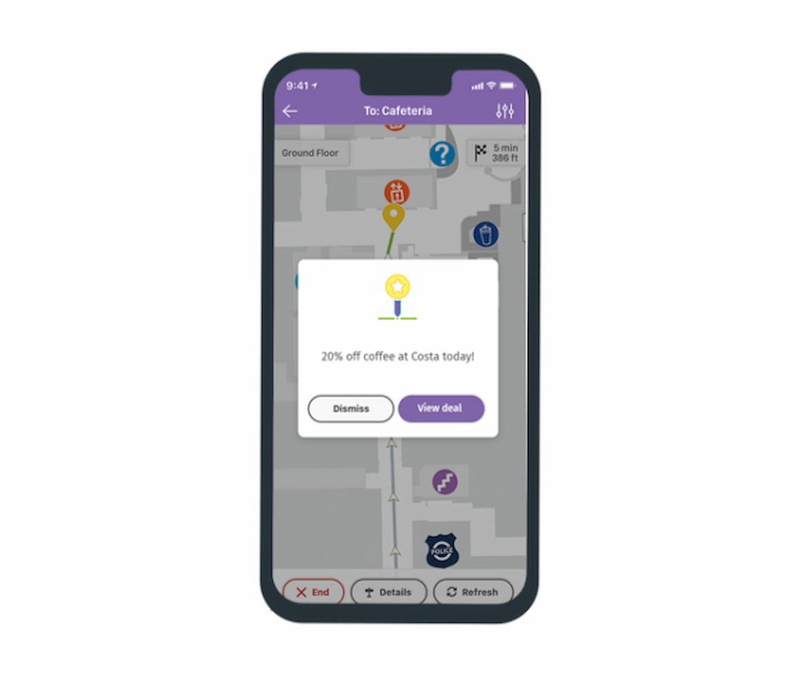
Purple is renowned for combining geofencing capabilities with advanced wayfinding solutions. Its proficiency in offering users directionally precise guidance while keeping them geographically aware solidifies its standing as the prime choice for wayfinding integration.
Why I Picked Purple: Amid the multitude of geofencing software I judged, Purple distinctly marked its territory. I chose Purple over others because of its unique capability to not only geofence but also incorporate advanced wayfinding. Given the growing need for tools that can guide users with precision while integrating geolocation, Purple seemed like the clear front-runner in this niche.
Standout features & integrations:
Purple's primary charm is its advanced wayfinding tools, allowing businesses to accurately guide their users. Its tools range from dynamic route recommendations to accessibility options for varied users.
Integration-wise, Purple meshes well with popular CRM systems, POS systems, and even some advanced IoT devices, making its applications wide and varied.
Pros and Cons
Pros:
- Integration capabilities with IoT devices
- High compatibility with CRM and POS systems
- Superior wayfinding tools with dynamic recommendations
Cons:
- Steeper learning curve for those unfamiliar with wayfinding tools
- Requires periodic updates to maintain wayfinding accuracy
- Might be specialized for those only seeking basic geofencing

Gimbal Location Platform provides a complete geolocation solution with tools for collecting, analyzing, and utilizing location data. It offers advanced capabilities for exploring location-based insights, providing a comprehensive understanding of any location.
Why I Picked Gimbal Location Platform: In my journey of comparing various platforms, I chose the Gimbal Location Platform for its breadth and depth of location functionalities. It stood out due to its all-inclusive features, painting a full picture of geolocation insights. This comprehensive nature solidified my opinion that it's the best fit for businesses wanting a wide lens on location analytics.
Standout features & integrations:
Gimbal offers geofencing, beacons, and detailed location analytics. This suite ensures businesses can precisely capture, interpret, and act on location data. Gimbal melds well with various third-party data tools and CRMs for integration, bringing forth a synergistic view of data and actionable insights.
Pros and Cons
Pros:
- Provides actionable and detailed location insights
- Integrates effectively with multiple third-party data tools and CRMs
- Comprehensive toolset including geofencing, beacons, and analytics
Cons:
- Potential steep learning curve for new users
- An annual commitment is mandatory
- Initial price point is on the higher end

GeoComply offers customized geolocation services to help businesses comply with regulations and prevent fraud. It's the preferred option for both compliance and fraud prevention.
Why I Picked GeoComply: I selected GeoComply for this list after carefully examining various geolocation services. The tool's dedication to regulatory compliance and its inherent mechanisms for fraud detection set it apart from other offerings in the market. It's clear to me that GeoComply shines brightest regarding providing fraud prevention and ensuring compliance.
Standout features & integrations:
GeoComply impresses with its real-time geolocation data collection, ensuring up-to-the-minute accuracy. Its pinpoint precision and customizable compliance zones provide businesses with the tools to effectively deter fraud.
Integration-wise, GeoComply has fostered partnerships with a broad range of online platforms and systems, solidifying its adaptability in diverse operational environments.
Pros and Cons
Pros:
- Broad integration capabilities with various online platforms
- Offers customizable compliance zones tailored for businesses
- Real-time geolocation data for utmost accuracy
Cons:
- Potential complexity in setting up for first-time users
- Requires continuous internet connectivity to function effectively
- Might be overkill for businesses with minimal compliance needs
Bluedot offers specialized geolocation services focusing on achieving precise location tracking for varied applications. With the increasing demand for detailed and accurate location-based insights, Bluedot delivers high-precision location data for businesses.
Why I Picked Bluedot: I chose Bluedot for geolocation tools due to its focus on accuracy and unique algorithms. It provides precise location services, which is crucial for businesses in need of detailed location information.
Standout features & integrations:
One of Bluedot's hallmark features is its ability to pinpoint location data in detail, offering insights that many tools overlook. In addition, Bluedot supports dynamic geofencing, adapting to real-world changes almost instantly.
Regarding integrations, Bluedot smoothly works with various marketing platforms, analytics tools, and CRM systems, making data transfer and analysis more straightforward.
Pros and Cons
Pros:
- Broad range of integrations for business applications
- Dynamic geofencing adjusts to real-time conditions
- Exceptional precision in location tracking
Cons:
- Precision features might come with a steeper learning curve for some users
- Annual billing might not appeal to all potential users
- Might be more intricate for users seeking basic geolocation features

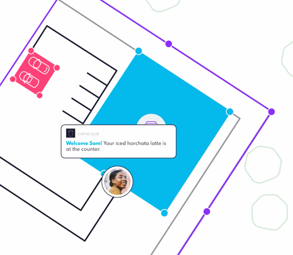
PlotProjects offers personalized geolocation solutions to enhance marketing strategies and engage customers more effectively with advanced location-based technologies.
Why I Picked PlotProjects: While comparing and judging various geolocation tools, PlotProjects emerged as a leader in its niche, tailored explicitly for marketers. Its unique blend of features, which focuses on location and customer interaction, differentiates it from other tools in the space. I chose PlotProjects because its offerings are directly aligned with the requirements of businesses aiming to leverage location data for heightened customer engagement and marketing efficacy.
Standout features & integrations:
PlotProjects boasts features such as real-time geotargeting, enabling businesses to send timely notifications to their audience based on location. Additionally, it offers rich analytics that provide insights into customer behavior and engagement patterns.
For integrations, PlotProjects meshes well with many marketing platforms, CRM systems, and even popular e-commerce tools, facilitating a cohesive workflow for businesses.
Pros and Cons
Pros:
- Extensive range of integration options with popular marketing tools
- Comprehensive analytics offering insights into engagement patterns
- Real-time geotargeting for immediate customer interactions
Cons:
- Requires a learning curve for those unfamiliar with advanced marketing techniques
- Pricing might be on the higher side for small enterprises
- Might be over-complex for businesses looking for basic geolocation solutions
Altri Software di Geofencing
Qui trovi alcune opzioni aggiuntive di software di geofencing che non sono entrate nella mia shortlist, ma che vale comunque la pena valutare:
- Roam.ai Geofencing API
For API-driven geolocation
- LocationSmart
For scalable geolocation needs
- Scalefusion
For multi-OS unified endpoint management
- Cisco Meraki
Good for cloud-based network management
- Hexnode
Good for robust mobile device geofencing management
- VMware Workspace ONE
Good for unified digital workspace integration
- IBM Security MaaS360
Good for comprehensive endpoint security management
- Simpli.fi
Good for foot traffic measurement and validation
- Mapbox
Good for custom map design and visualization
- Unacast
Good for high-resolution location data analytics
- Geoconcept
Good for optimizing geographic information processes


How I Evaluate Geofencing Software
I evaluate geofencing tools in two layers: the baseline every platform must have—polygon fencing, mobile ad delivery, and visit attribution—and the factors that separate one vendor from another.
Core Functionality (Table Stakes for This List)
These core capabilities serve as the acceptance criteria for inclusion on my list of geofencing software:
- Custom Geofence Creation: I check whether a platform supports both radius and polygon fencing so you can outline a competitor's parking lot or a full city block around a venue.
- Mobile Ad Serving: Each vendor's ad format support and inventory access matter—I look for display, video, and native delivery across both mobile web and in-app placements.
- Audience Retargeting: I evaluate how long a platform retains captured device IDs and whether it supports cross-device matching to re-engage shoppers who visited a trade show booth weeks ago.
- Foot Traffic Attribution: Connecting ad impressions to actual store visits is the whole point, so I look for control-group lift measurement and per-location visit reporting.
- Location Data & Targeting: Platforms that layer GPS, Wi-Fi, and SDK signals with demographic or behavioral filters give advertisers sharper reach than those relying on IP alone.
- Campaign Analytics Dashboard: I evaluate whether reporting goes beyond clicks and impressions to show visit lift, dwell time, and geographic heatmaps in real time.
I rank each vendor on a scale from 0 (does not offer the functionality) to 5 (excels in this area) for each criterion.
Vendors need to achieve a minimum average score to be considered for inclusion on my list. From there, I consider what sets each platform apart.
Differentiating Factors (What Sets Vendors Apart)
Once I've curated my list, here's how I contrast and compare different vendors in the geofencing software space:
Standout Features
I look for competitor conquesting tools that let you instantly target rival locations across regions, and addressable geofencing that enables precision household targeting for direct-mail-style campaigns. The depth of CRM and offline data onboarding is also key—vendors that can natively onboard first-party purchase data or build lookalike audiences based on past visitors offer you more sophisticated targeting workflows. For event-based advertisers, event and venue targeting tools that support scheduled, time-bound geofences add real value.
Beyond Features
Data privacy compliance is a major consideration—I check how each vendor handles sensitive-location exclusions, consent management, and readiness for post-IDFA identity frameworks. Service model matters just as much: some teams need a fully managed service with a dedicated strategist, while others want self-serve access to build and optimize campaigns independently. I also evaluate integrations with existing stacks, especially connectivity with analytics platforms, CDPs, and offline attribution providers that marketing teams already rely on.
Come Scegliere un Software di Geofencing
È facile perdersi tra lunghe liste di funzionalità e strutture di prezzo complesse. Per aiutarti a rimanere concentrato durante il processo di selezione del software più adatto a te, ecco una checklist di fattori da tenere presente:
| Fattore | Cosa Considerare |
|---|---|
| Scalabilità | Il software può crescere insieme alla tua azienda? Considera i limiti di utenti e quanto facilmente puoi espandere i servizi man mano che aumentano le tue esigenze. Fai attenzione ai costi nascosti. |
| Integrazioni | Funziona con i tuoi strumenti attuali? Controlla la compatibilità con CRM, analytics o altre piattaforme per evitare interruzioni nei flussi di lavoro. |
| Personalizzazione | Puoi adattare il software ai tuoi processi? Cerca opzioni per modificare impostazioni e funzionalità per soddisfare esigenze specifiche senza dover scrivere molto codice. |
| Facilità d’uso | L’interfaccia è intuitiva per il tuo team? Prova la demo per vedere se i membri del team riescono a utilizzarla senza formazione approfondita. |
| Implementazione e onboarding | Quanto tempo serve per la configurazione? Valuta la complessità dell’avvio iniziale e le risorse richieste per un onboarding efficace. |
| Costo | Il prezzo è in linea con il tuo budget? Confronta i modelli di abbonamento e cerca costi aggiuntivi o moduli obbligatori che potrebbero influire sul prezzo totale. |
| Tutele di sicurezza | Sono presenti misure di protezione dei dati? Verifica che il software rispetti standard di sicurezza pertinenti e offra crittografia e controlli sugli accessi. |
Che Cos’è un Software di Geofencing?
Il software di geofencing è uno strumento che crea confini virtuali intorno a luoghi fisici utilizzando GPS, Wi-Fi o dati mobili. Marketer, responsabili dei servizi sul campo, team di sicurezza e operatori di flotte lo usano per ricevere avvisi o avviare azioni quando persone o attrezzature entrano o escono da un'area. Questo ti aiuta a monitorare i team mobili, inviare messaggi basati sulla posizione e tenere traccia delle risorse, rendendo le operazioni quotidiane più fluide.
Funzionalità
Quando scegli un software di geofencing, presta attenzione alle seguenti funzionalità chiave:
- Monitoraggio in tempo reale: Monitora istantaneamente la posizione di risorse o persone, aiutandoti a prendere decisioni tempestive.
- Notifiche basate sulla posizione: Invia avvisi o messaggi quando si entra o si esce da aree designate, aumentando il coinvolgimento e il controllo operativo.
- Geotargeting: Prende di mira gli utenti in base alla posizione per campagne di marketing mirate, aumentando la rilevanza e l’impatto.
- Geofence personalizzabili: Ti permette di definire aree specifiche da monitorare, offrendo flessibilità per soddisfare esigenze diverse.
- Analisi dei dati e reportistica: Fornisce approfondimenti sulle attività basate sulla posizione, aiutandoti ad analizzare le tendenze e prendere decisioni informate.
- Capacità di integrazione: Si collega con sistemi esistenti come CRM o dispositivi IoT, garantendo un flusso di dati senza interruzioni tra le piattaforme.
- Controlli della privacy: Assicura che i dati degli utenti siano gestiti in modo sicuro, rispettando le normative sulla privacy.
- Semplicità d'uso: Presenta un'interfaccia intuitiva che semplifica la navigazione e riduce la curva di apprendimento per gli utenti.
- Supporto multilingue: Offre accessibilità a una base di utenti globale, migliorando l'usabilità in diverse regioni.
- Risorse di formazione e supporto: Fornisce materiali didattici e assistenza clienti per aiutare nell'utilizzo efficace dello strumento e nella risoluzione dei problemi.
Vantaggi
L’implementazione di un software di geofencing apporta diversi benefici al tuo team e alla tua azienda. Ecco alcuni vantaggi a cui puoi aspirare:
- Miglior targeting: Il geotargeting permette di raggiungere il pubblico giusto in base alla posizione, migliorando l'efficacia del marketing.
- Maggiore efficienza operativa: Il monitoraggio in tempo reale consente di controllare risorse e personale, facilitando decisioni rapide.
- Aumento del coinvolgimento: Le notifiche basate sulla posizione mantengono gli utenti informati e coinvolti con informazioni tempestive.
- Migliori approfondimenti sui dati: Le funzionalità di analisi e reportistica offrono preziose informazioni sulle attività basate sulla posizione, favorendo la pianificazione strategica.
- Flessibilità e personalizzazione: Geofence personalizzabili consentono di adattare lo strumento a necessità specifiche, offrendo versatilità in vari ambiti di applicazione.
- Sicurezza e conformità: I controlli per la privacy garantiscono la protezione dei dati, allineando le operazioni alle normative vigenti.
- Facilità di integrazione: Le funzionalità di integrazione consentono una connessione fluida con i sistemi esistenti, migliorando la continuità dei flussi di lavoro.
Costi e prezzi
La scelta di un software di geofencing richiede la comprensione dei diversi modelli e piani di prezzo disponibili. I costi variano in base alle funzionalità, al numero di utenti, ai componenti aggiuntivi e altro ancora. La tabella seguente riassume i piani più comuni, i prezzi medi e le caratteristiche tipiche incluse nelle soluzioni di software di geofencing:
Tabella comparativa dei piani per software di geofencing
| Tipologia di piano | Prezzo medio | Caratteristiche comuni |
|---|---|---|
| Piano gratuito | $0 | Geofencing di base, notifiche limitate e supporto della community. |
| Piano personale | $10-$30/user/month | Notifiche avanzate, geofence personalizzabili e analisi di base. |
| Piano business | $50-$100/user/month | Monitoraggio in tempo reale, capacità di integrazione e controlli avanzati sulla privacy. |
| Piano enterprise | $150-$300/user/month | Analisi approfondite, supporto dedicato e opzioni complete di personalizzazione. |
Domande frequenti sul software di geofencing
Ecco alcune risposte alle domande più comuni sul software di geofencing:
Come posso integrare il software di geofencing con il nostro stack tecnologico esistente?
Puoi integrare il software di geofencing utilizzando API, SDK o webhook forniti dalle principali piattaforme. La maggior parte delle soluzioni enterprise supporta i linguaggi di programmazione più diffusi e offre documentazione tecnica dettagliata. Cerca opzioni che si collegano con il tuo attuale CRM, app mobili o servizi di localizzazione. Testa le integrazioni in un ambiente sandbox prima della distribuzione in produzione. Se hai sistemi legacy, verifica la disponibilità di middleware o consulta il fornitore per un supporto all’integrazione personalizzata.
Quali sono le considerazioni relative alla privacy dei dati o alla conformità con il software di geofencing?
Devi assicurarti che il tuo software di geofencing sia conforme alle leggi regionali sulla privacy dei dati come il GDPR o il CCPA. I dati di localizzazione sono sensibili, quindi privilegia fornitori che offrano crittografia dei dati, politiche di conservazione personalizzabili e strumenti chiari per il consenso dell’utente. Valuta se i dati di posizione sono archiviati, trasmessi o elaborati localmente o nel cloud. Collabora strettamente con i team legali e di conformità per definire processi di autorizzazione e audit.
Il software di geofencing può scalare con una forza lavoro o una flotta globale?
Sì, la maggior parte delle soluzioni di geofencing di livello enterprise può scalare a livello globale. Scegli software con supporto multiregionale, un’infrastruttura ad alta disponibilità e limiti robusti per le chiamate API. Verifica che la piattaforma supporti un gran numero di geofence simultanei e il tracciamento in tempo reale. Se gestisci una forza lavoro o una flotta distribuita, conferma la compatibilità con vari tipi di dispositivi e reti di telecomunicazione locali.
Quanto è affidabile il geofencing in ambienti con GPS instabile o connetività scarsa?
Il software di geofencing può gestire segnali GPS non affidabili o deboli segnali cellulari, ma i risultati possono variare. Cerca piattaforme che supportino trigger basati su Wi-Fi o Bluetooth come backup. Alcuni strumenti utilizzano tecnologie di localizzazione ibride per migliorare la precisione all’interno di edifici o in zone urbane complesse. Effettua sempre un test pilota della soluzione in ambienti difficili per valutare ritardi, falsi avvisi o check-in mancati prima di una distribuzione completa.
Cosa succede ora:
Se stai valutando software di geofencing, collegati gratuitamente con un consulente SoftwareSelect per ricevere raccomandazioni.
Compila un modulo e fai una breve chiacchierata durante la quale approfondiranno le tue esigenze specifiche. Poi riceverai una shortlist di software da valutare. Ti supporteranno anche durante tutto il processo di acquisto, incluse le trattative sui prezzi.